
FIRST CROP CIRCLES IN THE USA – 2007
ERSTE KORNKREISE IN DEN USA – 2007
UPDATE: 17. Mai 2007 (scroll down for the red marked updates...)
…zur deutschen Fassung
In early May, the first crop circle formations in the United States of America were discovered in the states of Louisiana and California.
THE FIRST FORMATION was reported on May 10, 2007, by local TV-station NBC10 to have been discovered the week before from the air by local pilots. The formation is said to resemble „over 25 circles“ in a field of wheat at the village of Epps in West Carroll Parish in northeast Louisiana.
We expect to be able to show an aerial video-still of the formation at Epps, Louisiana soon...
Copyright: NBC10 - www.www.region10.com
Aerial footage of the formation (unfortunately low in resolution) can be seen here
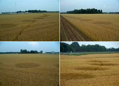
Video-stills showing the circles in the field.
Copyright: NBC10 - www.region10.com
+ + + GET OUR FREE CROP CIRCLE NEWSLETTER HERE + + +
The original article on NBC10 reported the following:
„The small farming community of Epps has found itself in the spotlight after a series of crop circles appeared in a local wheat field.
Until now northeast Louisiana farmers never had to deal with the crop circle craze. That is until a local pilot flew over a West Carroll parish wheat field earlier this week. There's something unusual going on in this West Carroll parish wheat field. Bobby Gwin who lives near the field tells us, "Something happened didn't it? but what I don't know. I couldn't say". West Carroll creditor Adam Plunkett says, "I have never seen anything like it in twenty years of flying". What's perplexing people in West Carroll parish? Crop circles. A local creditor spotted this odd formation from the air and reported it.
Ag scientist from the Louisiana State Agricultural Center went to the field to see the circles. Ralph Bagwell from the LSU ag center says that this phenomenon is strictly man-made". The LSU team concluded that sometime last year one or more persons used a common insecticide and a pre measured piece of rope or a board. The end result? Over twenty five circles, approximately ten feet in diameter that stretch almost a quarter of a mile. So what at first glance appeared as an out of this world event in an Ark-La-Miss wheat field, turned out to be a good old fashioned prank. (...)"
American crop circle researcher Jeff Wilson, director of the "Independent Crop Circle Researchers’ Association (ICCRA)“ noted that the formation seems to be placed „very close one of the oldest (about 1670 B.C.) and largest Indian mound complexes in the USA, called Poverty Point.“
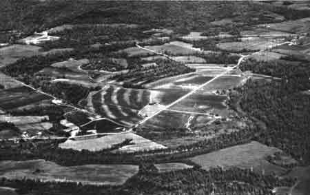
Aerial of “Poverty Point” near Epps
Copyright: National Park Service / Public Domain
So far we do not know what kind of analysis and methods have been used by the Ag scientitsts at the site, nor if the team was aware of the state of physiological crop circle sciences.
However, it sounds rather suprising that the scientific conclusion should state - as quoted by NBC10 - that the formation was made "last year". This might imply that the formation was not a typical flattened crop circle formation but - as some of the above shown pictures suggest too - that the circles became visible due to different growing levels only and not by the fact that the normal growing plants had been flattened.
Furthermore it sounds strange that using "insecticides" (a pesticide used to kill insects) and not "herbicides" (to kill unwanted plants) was the way the circles shold have been made while at the same time the using of "a pre measured rope or a board" was suggested.
Both details as well as the above mentioned "last year-theory" might be due to journalistic misinterpretation of the possibly expresses idea by the Ag scientists that in fact the plants were treated already "last year" (when still very young) with some sort of "herbicide" and that "a pre measured rope or board" was used to mark out the circular size and areas. This would imply that the circle's plants were not flattened but only lower in growth than the surrounding normal field. In this case the formation of circles at Epps would not represent a classical crop circle formation. However based on the report, the farmer does not seem to have been informed about such activities.
A newsreport by American station TV8 now shows the circle in better close-ups. The picture reveal that indeed the circles were not flattened in the normal crop circle way but were only lower in growth. The owning farming farming family says that they did not do this.
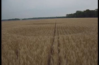
Still taken from TV8 newsreport at: http://www.knoe.com/headlines/fullstory.php?id=1528
At the moment we are trying to get an interview the above quoted Professor Ralph Bagwell from the LSU. We will update this report as soon as more information will be available...
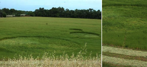
THE SECOND FORMATION was reported on May 12, 2007, by the local newspaper „Red Bluff Daily News“.
Copyright by www.redbluffdailynews.com / Rebecca Wolf
As the newspaper reported, the formation of three circles of different sizes was discovered on May 11, in a „field across the street from Helser Chevrolet on Adobe Road in Red Bluff in Tehama County, California. Red Bluff police said they were aware of the circles but had not received any calls on the matter and were not investigating."
Again Jeff Wilson of ICCRA supplied the following information on the formation's location:
"Red Bluff, California is notable as being the location of where Ishi, “the last wild Indian in North America,” came out of the wilderness (just to the west of Red Bluff) back in 1911; Ishi was the last remaining member of the Yahi tribe. There were Indian mounds that were excavated in Red Bluff (the Tehama-Red Bluff Mounds) back in 1907, and there are more than 250 recorded ancient settlement sites along the Sacramento River in Tehama County. Red Bluff is located about 40 miles south of Mt. Shasta and 40 miles west of the Lassen Volcanic National Park."
Sources and Thanks: www.region10.com, www.redbluffdailynews.com, J. Wilson, ICCRA, P. Duckworth, R. Wolf
SUPPORT OUR RESEARCH AND VISIT OUR NEW CROP CIRCLE SHOP - Thank You!

ERSTE KORNKREISE IN DEN USA – 2007
Aktualisiert: 17. Mai 2007 (im Folgenden rot markiert)
In den ersten beiden Maiwochen wurden die ersten Kornkreise des Jahres 2007 nun auch in den USA entdeckt.
DIE ERSTE FORMATION wurde am 10. Mai vom lokalen TV-Sender NBC10 gemeldet. Entdeckt wurde sie bereits in der Vorwoche von lokalen Piloten und befindet sich in einem Weizenfeld bei Epps in West Carroll Parish in Nordosten des US-Bundesstaates Louisiana. In einem Bericht des Senders heißt es, die Formation bestehe aus mehr als 25 Kreisen, die sich bogenförmig auf einer Länge von etwa 500 Metern über das Feld verteilt sind.
In Kürze erwarten wir an dieser Stelle ein Luftbild der Formation zeigen zu könne...
Copyright: NBC10 - www.region10.com
Luftbildfilmaufnahmen der Formation (ledir in geringer Qualität) finden Sie hier
Standbilder der TV-Filmaufnahmen mit freundlicher Genehmigung zur Verfügung gestellt von NBC10.
Copyright: NBC10 - www.region10.com
Im Originalbericht von NNC10 heißt es, dass die Kornkreisformation von einem Team von Agrarwissenschaftlern des “Louisiana State Agricultural Center” unter Professor Ralph Bagwell untersucht wurde. Dieses zeigt sich überzeugt davon, dass die Kornkreise ausschließlich von Menschen verursacht wurden. Das Team der LSU nimmt an, dass “bereits im vergangenen Jahr eine oder mehrer Personen übliche Insektizide, ein zuvor abgemessenes Sein oder ein Brett” verwendet haben. (…)”
Der amerikanische Kornkreisforscher Jeff Wilson, von der "Independent Crop Circle Researchers’ Association (ICCRA)“ merkt zu den Meldungen an, dass die Formation in unmittelbarer Nähe zu einem der ältesten indianischen Erdhügelanlagen (ca. 1670 v. Chr.) der USA, dem sogenannten Poverty Point platziert ist.
Luftbild des “Poverty Point” nahe Epps.
Copyright: National Park Service / Public Domain
Bisher ist uns nicht bekannt, welche Methode und Analyseverfahren die Wissenschaftler der LSU in den kreisen angewewedent haben. Ebensowenig ist bekannt, ob sie über den Stand der Kornkreisforschung informiert sind.
Zumindest klingt es merkwürdig, wenn die Wissenschaftler angbelich schlußfolgern, die Kornkreisformation sei bereits im "vergangenen Jahr" angelegt worden.
Auch ist unklar, warum zum Herstellen der Kreise einserseits "Insektizide" (also eine Substanz, die zur Abtötung von Insekten) und keine "Herbizide" (also Unkrautbekämpfungsmittel) verwendet worden sein sollen, während gleichzeitig behauptet wird, dass die Kreise wohl mit einem " vorab abgemessenene Seil oder einem Brett" angelegt wurden.
Möglicherweise erklären sich diese Ungereimtheiten jedoch schlicht und einfach durch eine journalistische Fehlinterpretation. Demnach könnten die Kreise bereits im Vorjahr durch das aufbringen von Herbiziden auf die noch jungen Keimlinge angelegt worden sein, wobei die Kreise durch ein zuvor abgemessenes Seil oder mit einem Brett abgemessen worden wären. In diesem Fall würde es sich jedoch nicht um eine klassische "Kornkreis"-Formation handeln, da die Pflanzen nicht niedergelegt wurden, sondern sich die Kreise lediglich durch unterschiedlchen Wuchs abzeichnen. Diese Ansicht sceint sich auf einigen der oben gezeigten Bilder ansatzweise zu bestätigen.
Wie dem auch sei, zumindest laut Originalbericht scheint der Farmer nichts von derartigen Aktivitäten zu wissen.
EIn weitere Nachrichtenbericht des amerikanischen "TV8" zeigte genauere Bilder der kreise im feld. Diee bestätigen den eindruck, dass es sich hierbei nicht um klasssich niedergelegte Kornkreise handelt, sondern dass das Getreide in den Kriesflächen lediglich niederiger steht. Was die Kreise jedoch verursacht hat, ist weiterhin unbekannt. Die Farmersfmilie schwört, für die Kreise nicht verantwortlich zu sein.
Standebild der Nachrichtensendung auf TV8: http://www.knoe.com/headlines/fullstory.php?id=1528
Zurzeit bemühen wir uns um ein Interview mit dem zitierten Professor Ralph Bagwell und werden diesen Bericht aktualisieren, sobald uns weitere Informationen vorliegen...
DIE ZWEITE FORMATION wurde am 11. Mai bei Red Bluff im Tehama County im US-Bundesstaat Kalifornien entdeckt und von der Lokalzeitung „Red Bluff Daily News“. Gemeldet.
Copyright by www.redbluffdailynews.com / Rebecca Wolf
Wie die örtliche Polizei bestätigte, wisse man zwar von den Kornkreisen, bisher habe jedoch noch niemand Anzeige erstattet, weswegen man auch keine genauer Untersuchung anstrebe.
Zum Ort der Kornkreisformation von Red Bluff weiß Jeff Wilson (ICCRA) folgende Informationen zu berichten: "Red Bluff in Kalifornien ist bekannt dafür, dass hier "Ishi", der letzte wilde Indianer Noramerikas" die Wildniss im Jahre 1911 velrassen haben soll. Ishi war der letzte Eingeborene des Stammes der Yahi. Im Jahre 1907 wurden hier zahlreiche Indianische Grabhügel ausgegraben. 250 dieser Anlagen entlang des Sacramento River sind bis heute im Tehama County bekannt. Red Bluff liegt etwa 40 Meilen südlich des Mount Shasta and 40 Meilen westlich des "lassen Volcanic National Park."
Quellen und Dank: www.region10.com, www.redbluffdailynews.com, Jeff Wilson, ICCRA, P. Duckworth, R. Wolf
UNTERSTÜTZEN SIE UNSERE FORSCHUNG - Vielen Dank!